Weather certainly makes a difference when it comes to running. Take a look at the breaking 2 project – where conditions were carefully selected in order to produce the best possible results. There is a reason why they chose to run it in Monza, Italy, where conditions are much cooler and not Sepang Track, Malaysia or F1 Track in Singapore. This is also why you don’t see World Records being run in sunny Malaysia or blistering hot Hawaii. They are usually run in cooler conditions such as Berlin and London.
Running In Cold Weather Improves Performance
Running in the cold can be difficult – with the strong icy winds. It’s much easier to stay in under a warm blanket and hibernate. However, the cold weather actually is much more conducive training weather. This is because – in cold conditions, your body is put under less stress. Running at a 5-minute pace in cold weather puts less stress on your body as compared to running the same pace in hot weather.
Why?
This is because the running motion produces heat as a byproduct when producing energy. Our body needs to lose this heat to avoid a build-up of heat which can be damaging to our body. Think – heat stroke! One mechanism to lose heat is sweating. However, when we sweat, our body also becomes dehydrated. Another mechanism is by transporting this heat to the surface of our skin. This makes your heart work harder. So, the dehydration and the additional work your heart has to do puts your body under more stress.
Photo Credits: Gear Patrol
This means that running the exact same pace in colder weather takes less effort and less energy. Your body is also put under less stress and less pressure.
Potential Problems
One of the leading myths is that in colder weather, your body has to burn more calories in order to keep your body warm. However, it is important to note that this amount of additional calories is a negligible amount. You can mitigate this risk by wearing suitable clothing to keep your core temperature warm. Pro tip: Use rechargeable hand warmers to keep your hands warms during your run.
What you should be taking note of is that in cold weather, your body relies more heavily on glycogen rather than fat as an energy source. So, in order to prevent yourself from hitting the wall, you should take an extra packet of gel as compared to racing in warmer conditions.
Also, it is easy to forget to hydrate yourself. You may not exactly feel thirsty as the lower temperatures prevent you from getting the thirst sensation. However, the possibility of dehydration is very real. Have a hydration strategy and stick to it regardless of whether or not you feel thirsty.
Keeping to this – pick a race in ideal cooler conditions and you are on your way to hitting a personal best!
In a recent study, researchers from RunRepeat.com analyzed marathon timings in Australia from 2000 to 2016 and concluded that Aussies have never been slower. Their database includes 183,061 results from 154 different races.
When they plotted the mean finishing times year after year (figure shown above), they observed a trend that indicates that Australian marathon participants have been getting progressively slower for the last 17 years. It is important to note that there is an average increase of about 20 mins in the average finishing time of a marathon in 2017, compared to 1999.
A number of different reasons could be responsible for this trend. Some of them are:
The overall increased participation;
The increased numbers of female participants;
The increase of the average age of the participants.
However, what they have found is that these reasons can not explain the trend entirely.
Increased Participation
It is true that the numbers of marathoners have increased in the last 17 years. This might mean that the more popular marathon running becomes, more and more unprepared participants join and they drag the average down. However, when the finisher times are segmented by speed, slowing down across all groups was observed. Additionally, the percentage of people, who just walk the race has been and still is minuscule and cannot be responsible for the overall increase in finishing times.
Increased Female Participants
As we know women are on average slower than men and with more women, the average time goes down. However, when data were segmented by gender, it was found that men and women are slowing down at equal rates, as shown in the plot below:
Aging Population
Interestingly, contrary to the global trend, the average age of marathoners in Australia has been slightly declining. Such an argument, therefore cannot be valid.
What about health?
Obesity in Australia, as in most developed countries, is on the rise. Researchers Andersen and Nikolova used the data on obesity from the Australian Bureau of Statistics and what they found is that both obesity and hypertension trends correlate strongly with the slow-down trend, both when studied in short- and long-term.
It is important to note that correlation is not causation and we can’t be sure that these results are the complete and only explanation for the slowdown of Australian marathoners, but it is worth noting that the deteriorating health seems to have an impact even on the more active and health-conscious marathon runners.
A VERY different type of fun obstacle course will happen this coming March 25 at the Amoranto Stadium in Quezon City entitled “Awareness for Wellness: Speed Bump Obstacle Course”. The said event is staged by the husband wife team of Dr. Rob Walcher and actress Patricia Javier.
Over 10 various kinds of obstacles will spread all over the venue and participants may choose between running four or two kilometers. Part of the proceeds will go to the Hope For Lupus Foundation.
For sure everyone’s strength, agility, speed and sill will be put to the test but they can be assured that the obstacles will be just right that even kids could do them. Aside for the race itself, other activities have been prepared to complete the Sunday morning family day experience.
Registration is now ongoing at Garmin branches located at Glorietta 5, Uptown Mall BGC, Alabang Town Center, SM Mall of Asia, SM Megamall and SM City North EDSA. The race kit includes a sublimated print t-shirt and a race belt to hold one’s number.
Both the four and two-kilometer categories carry the same registration fee of only PHP 700.00. Participants will also get the chance to race with surprise guest celebrities.
The event is made possible with the assistance of the Pinoy Aspiring Runners (PAR) and also marks the birthday of Dr. Walcher, a chiropractor. “My business is to make people feel good by aligning their spine and that will benefit all especially runners and athletes,” he said.
Formerly based in California and with two growing sons, the family made the decision to relocate to the Philippines in 2015 and since then, Dr. Walcher has established two clinics in Quezon City and Makati City. For more information, please visit www.DocRobChiro.com.
We all know dreams require sacrifice, so, what are you willing to give up to get to your dreams? It’s really about how bad you want it! Do you want it bad enough to put in the sweat blood and tears? It is the mental fortitude that makes the difference between a good athlete and a great athlete. It’s this mental toughness that can push you through your physical limits. This is also the reason why the fastest race course is a course with the loudest spectators. Because they give you this mental boost.
Check out these inspiring moments that show us how badly these athletes want it!
#1 Devon Bailing
Just shy of the finishing line, Devon Bailing collapsed due to exhaustion. But, she wanted to finish the race so badly. She could not get up, so, she rolled. She completed her race in 3 hours 34 minutes, an impressive time with a unique finish!
#2 Paula Radcliffe
Back in 2005 during the London Marathon, Paula Radcliffe wanted to go for the World Record. She wanted it bad. She was having stomach cramps mid-race and really needed to go. She relieved herself in front of the hundreds and thousands of people watching her attempt at the World Record. But it was all worth it, because she ran a 2:17:42 marathon.
#3 No Legs, No Problem!
This dude is one of the most inspirational people. Despite his disability, he displayed true strength and grit. He shows is that truly nothing is impossible if put our mind to it! His never give up attitude inspires admiration and respect. This is one of the most amazing things I’ve seen.
Remember, everything is achievable if we set our mind to it! There is nothing that is impossible. Our mind is stronger than we think it is. It’s about how badly you want it! So, how bad do you want it?
The Performance Series (TPS) is coming back this year in its 3rd edition and it will bring runners to FOUR different locations:
22 April – Punggol Waterway
24 June – Pasir Ris
5 August – Bedok Reservoir
14 October – East Coast
Before we go into any further, there’s a VERY IMPORTANT info for you: In order to maximise every participant’s race-day experience, each TPS 2018 race will be capped at 3,500 registered participants. So before you missed out this, check out the 5 things that you should know about TPS 2018.
#Back to Basic: 5km or 10km, across Singapore
“Simplicity. Identify the essential. Eliminate the rest.” This year, TPS is going back to basic by bringing participants to run 5km or 10km at four interesting venues across Singapore. You can challenge yourself to achieve a new Personal Best in 5km or 10km, or you can invite your friends and family to run with you in this more manageable distance.
Series Finisher Medals
First ever in Singapore, The Performance Series 2018 is introducing a Finisher Medals Collection that featuring Singapore Nature & Wildlife, Singapore Heritage and Uniquely Singapore. Does each of them look familiar to you?
Series Finisher Tees
Do you get bored of the usual Finisher Tees design? TPS has something fresh and cool for you! Classic, yet extraordinary. You will definitely want to put these on you every day.
Series Event Tees
Stay with TPS throughout the #TranscendYourself journey: RUN, AIM, TRAIN and REACH. Check out the bright colours TPS 2018 Series Event Tees:
Get on board and become one of The Performance Series Athlete.
“We run together, we explore together and we transcend together! Together we do great things.”
2018 TPS Ambassadors
If you are a competitive runner, there’s a chance for you to win the prizes; if you have a great transcend story to share, you can be one of the 2018 TPS Ambassadors! TPS will be rewarding 4 transformations with S$1,000 cash each. More information about this – a first for Singapore – will be announced soon!
So if you have not signed up TPS 2018, hurry up and get your slot at a discounted bundle price!
Many runners have the Boston dream. They put in the time, effort and dedication in hopes of running a Boston Qualifying time. It is a privilege and an honour to run the Boston Marathon – not everyone can run the Boston Marathon. First, you must run a Boston Qualifying time. But, you must be among the fastest applicants to be accepted to run the race. This year, qualifiers who were 3 minutes 23 seconds or faster than the qualifying time for their age group and gender were accepted into the 2018 Boston Marathon. So, if you are accepted to run the Boston Marathon, you are surely within the top 10 – 15 percent of your age group.
Toronto’s Soroush Hatami, ran a 3:05:42 at the 2016 Scotiabank Toronto Waterfront Marathon, running well under the 3:10:00 mark required for his age group. He was ecstatic. It’s not easy to be able to run the Boston Marathon but for Hatami, it was even harder.
For Hatami, it wasn’t running a qualifying time that was the challenge, it was because of his passport. Hatami has lived in Toronto since 2013 and is a permanent resident of Canada. He is currently in the process of applying for his Canadian Citizenship. He however still holds an Iran passport.
When Trump was elected President, Trump imposed a ban blocking citizens of several Muslim countries from entering the United States. Iran was one of the countries on the ban list. He has accepted that it is unlikely he would be able to run his Boston dream.
In light of his current situation, Hatami realizes how this ban adversely affects so many people. This ban doesn’t just affect runners, but students, families and medical patients from entering the country. Together with Marathon Dynamics runner Daniel Sellers, they have come up with a project aimed at raising funds for the Muslim Advocates legal organization and the International Refugee Assistance Program. These 2 groups working to oppose the travel ban and support people affected by it.
They are hoping to raise a total amount of $26,000, $1,000 for every mile of the marathon. Their cause is a worthy and interesting one – check them out!
Source: Running magazine.ca, Banned on the run 2018
Running has been given a bad name by some. Didn’t you know it strains your heart and it’ll hurt your knees, so don’t do too much running! Haven’t you heard about the guy who died of a heart attack running the marathon last weekend? We’ve heard it all before! But, running isn’t bad. You’ve been misled and misinformed.
#1 Running Is Not Bad For The Knees
You know who you hear this from? You guessed it right – non-runners. In fact, running helps strengthen your knees and joints according to research. On the other hand, lazing around sitting in front of the tv with your favorite crisps? Now that is bad for your health, and your joints, and your arteries, and your lungs, and your heart, and your mental health.
#2 1 Hour Of Running Adds To 7 Hours Of Your Life
According to an article written by Alex Hutchinson, an hour of running adds an additional 7 hours to your life. He points out that this is calculated based on relatively minimal amounts of running. The more you run, the more you gain out of it. Assuming you run for 3 hours a week, that would be 156 hours of running a year. That would add 1092 hours to your life which is roughly 1.5 months of additional life. If u were running for 10 years, that would be 15 years of additional life. Interesting isn’t it? Imagine the things you could do with an extra 15 years!
We know that there are a couple of cases here and there about runners dying from a heart attack mid-marathon. However, we must stress that it is not running that causes the heart attack. It is paramount to always go for a body check up to know how much stress you can put on your heart. If you have a blocked artery or two, you shouldn’t be stressing yourself out too much. You can still benefit from running, however, perhaps use a heart rate monitor to keep yourself in check and avoid pushing yourself too hard.
A NEW race series is sure to attract the attention of many starting this April 15 – “Takbo PARa Sa Kalikasan” consists of four separate fun runs this year staged by the Pinoy Aspiring Runners (PAR) and MnK Concept and Events with the advocacy of protecting the environment. The first race, Fire Run, will be at the Liwasang Ulalim inside the Cultural Center of the Philippines Complex with Haribon Foundation as the event’s main beneficiary.
Runners may join either 16, 10, five or three kilometers with the corresponding registration fees of PHP 850.00, PHP 750.00, PHP 650.00 and PHP 550.00 respectively. All race kits are inclusive of a singlet and race bib number plus all finishers will be awarded a medal upon crossing the finish line with 16-kilometer participants getting an additional t-shirt as well.
Onsite registration is now being conducted at Garmin branches located at SM Mall of Asia, SM Megamall, SM City North EDSA, Alabang Town Center, Glorietta 5 and Uptown Mall BGC. Promos and discounts await those who will register for the entire series or sign up in bulk as a group or team.
After the Fire Run, the series will continue with the Water Run on June 17 and the Air Run on September 30. The series will culminate with the Earth Run on November 18 which is sure to be a hit not just with runners but also their families as several side activities are in the plans.
The four medals can be combined to form one big medal. There will be increasing distance categories as the series progresses and everyone is sure to look forward to the four collectible singlets from each leg.
“We may not be aware or care about climate change these days because we are already used to it but that should not be the case as global warming is a very big problem,” said PAR President Joseph Balbino during the recent media launch. “We decided to adopt an environmental advocacy this time after conducting many charity fun runs.”
Meanwhile, PAR also used the occasion to introduce their new website, www.par.com.ph and also their PAR Loyalty Card which may be used to avail of discounts or earn points when joining events or patronizing partner shops and restaurants. PAR has also lined up several other events for the year so watch out for it very soon.
For the latest information and updates, please visit and like Fire Run on Facebook.
From Taiwan, Tan (陳淑娟) 40 years old with 2 kids, but she had a dream. She had the Boston dream.
She is the epitome of it is never too late to start. She started running late, but that did not mean she could not hit her dream. She believed that although she started late, with determination and perseverance, she would be able to run a Boston Qualifying time. She said believing in yourself is more important than a hundred other people believing in you. She believes that you should never underestimate your ability – because if she can, everyone can too.
The Boston Dream
The Boston dream isn’t just about running the Boston Marathon. It’s a journey. It starts with a race, and can become many races (if you fail) – in hopes of running a Boston Qualifying time. Hitting the mark is not a guaranteed acceptance. Only the fastest applicants will be accepted to run the race. This year Qualifiers who were 3 minutes, 23 seconds (3:23) or faster than the Qualifying time for their age group and gender were accepted into the 2018 Boston Marathon. So, you can rest be assured that if you are running the Boston Marathon, you are running amongst the best.
She ran the beautiful Tarako Gorge Marathon and surprised herself with a personal best of 3 hours 38 minutes. She had hit her Boston Qualifying mark for her age group. However, given that only the fastest timings would be accepted, she was worried a 3 hours 38 minutes would not be good enough. She set her eyes on running a timing well under the BQ mark – a sub 3 hour 25 minutes marathon.
As Usain Bolt would put it, the race part is the easy part, what you don’t see – the training, the tears, the sweat, the blood, that’s the hard part. So she knew she needed to buck up in training to hit a sub 3:25:00 marathon. She knew dreams require sacrifice – so how far are you willing to go to hit your dreams?
She had to strike a good balance between – work, family and training. She incorporated speed work into her training. She sacrificed sleep to do her long runs on the weekend. She was discipline with foam rollong and stretching to prevent her from incurring any possible injuries. Although it sounds exhausting, but she said she never once felt tired. Because she knew with every step she took, she was getting herself one step closer to her dream.
The weather was cooling on race day – Standard Chartered Taipei Marathon. She told herself to trust her training, trust the process, and results willl naturally speak for itself. The first 30 km went according to plan. But after the 30 km mark, fatigue started to settle in. Her pace dropped slighlty. However, a sub 3:25:00 was still possible if she could maintain her pace for the final 12 kilometers. She wasn’t ready to give up. Her boyfriend, knowing how important this run was to her decided to pace her. He encouraged her, reminded her to fuel and hydrate herself – and it was his act of putting aside his own goals that pushed her to not give up.
She ran the Standard Chartered Taipei Marathon in an impressive 3:24:57 (Gun time). What a stellar run with a brand new personal best.
And that’s her ticket to Boston!
So, remember, it’s never too late to start chasing your dreams. You just need to start!
Almost 150 women took to the streets of Bengaluru dressed in Sarees. Looking glamorous in the traditional Indian dress, you would think they were there for a wedding. You would never think that they were there to run. Some women even had babies strapped to their chest whilst they ran the 3-kilometer route along the 100-feet road.
The run was organized with the aim of raising awareness about women’s health and breast cancer. Some women ran the 3 kilometers in an impressive 15 minutes but the average women took approximately 30 minutes to complete the distance.
Photo Credits: Decan Chronicle
Upon completion of the run, women shared inspiring stories. They shared personal stories about breast cancer – the battle and their journey. They talked about breast cancer – prevention and the significance of early detection. They shared the importance of health to them. Everyone had their own stories of strength, hope, determination, failure and sadness that could inspire anyone. The stories shared told one narrative – to believe in yourself and that you have the strength within yourself to resolve anything.
Photo Credits: The News Minute
It was a great run, with a great cause. Thank you, women!
Prepare yourself for an exciting galactic adventure when STAR WARS™ RUN returns this May. As part of the ‘May the 4th’ celebrations, The Walt Disney Company Southeast Asia and local organizer Esprimo once again brings us the STAR WARS RUN Singapore on the 5th May 2018.
STAR WARS fans can look forward to another great event after it’s inaugural edition last year. This year, the Marina Bay area and the F1 Pit Building will be transformed – bringing to all STAR WARS fans a unique event themed around the iconic storyline and characters from the franchise. Fun activities at the Race Village will include STAR WARS themed activities, interactions, food, and beverages as well as an outdoor movie screening of STAR WARS movies.It will be a great immersive experience – being transported to a galaxy far, far away.
Join The Rebellion, Or Come To The Dark Side
Will you walk in Darth Vader’s footsteps to uncover the great powers of the dark side, or join the Rebellion on their plight for justice on the light side? – two sides, one choice, but both routes will feature engagement zones that will bring the STAR WARS experience to life with music and light projections and fun photo opportunities.
New Flag-Off Format and Run Category for Kids
Increasing from two to three categories this year, STAR WARS RUN Singapore 2018 aims to cater to fans of all ages and fitness levels. On top of the competitive 10km and non-competitive 5.4km, the inaugural 540m Young Jedi Dash for younger children will be added to this second edition. Runners will also be part of a first-of-its-kind flag-off where the Light and Dark side participants for the non-competitive 5.4km will run in opposite directions.
Registration
Loyal Runners (those who registered for STAR WARS RUN Singapore 2017) and early sign-ups can enjoy a special registration price from now until 14 March 2018. Priority registration is also exclusively open to Loyal Runners for the first seven days, with limited slots available. Pledge your allegiance by 14th March at www.starwarsrun.sg to enjoy early bird rates! #StarWarsRunSG
All running enthusiasts who are brave enough to take on the challenge will receive exclusive STAR WARS RUN merchandise. Finishers of the 10km & 5.4km category will also receive a commemorative medal unique to their category and finisher t-shirt. Designs vary depending on the side you choose.
JustRunLah! is proud to be the Official Running & Fitness Portal for the STAR WARS RUN 2018!
The RAK Half marathon was a highly anticipated one – with big names to run the race. Everyone was looking forward to watching the battle between 2 elites in particular – World Marathon record holder, Mary Keitany and World Half Marathon record holder Joyciline Jepkosgei. Everyone wanted to see who would come out on top. 2 World Record Holders, but only one can emerge champion.
However, the much-anticipated clash didn’t quite materialize. Joyciline Jepkosgei was not feeling her best having caught a flu bug 2 weeks ago. She dropped out of the leading back slightly after the halfway mark to come back 5th in a respected time of 1:06:46. However, that did not mean it was an easy win for Mary Keitany.
It was 23-year-old Fancy Chemutai that stole the show. She demonstrated greater strength and speed than Mary Keitany over the final 100 meters of the race. She out-sprinted Mary Keitany to come home in a 1:04:52. She was only 1 second outside the World Half Marathon record set by Joycline Jepkosgei back in Valencia last year. Mary Keitany came back 3 seconds later with another personal best for her.
In the men’s race, Bedan Karoki, defending champion took home the crown again. At the 19th km point, he put in a test surge where there was no response. It was then all him all the way till the finishing line.
Both Champions are set to run the World Half Marathon Championships in Valencia.
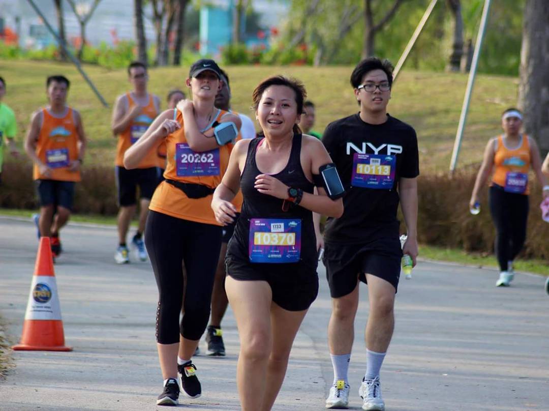
Blur sotong me! Mistaken the date of Safari Zoo Run, I thought it’s supposed to be on Sunday! ? On that Saturday, I even woke up early and roll on bed, watched a few episodes of Drama of the Empress Wei Zi Fu on YouTube, happily go buy lunch then nua till afternoon, then I was scrolling Instagram and I almost heart attack when I saw people posting photos of medals and photos of them at zoo run. Limbu missed a sibeh memorable run! ? It’s a run where Limbu first met my stead leh and I missed it just like this! ? (Limbu eh engleash standlerd is wers dan Premium Lian lah ?)
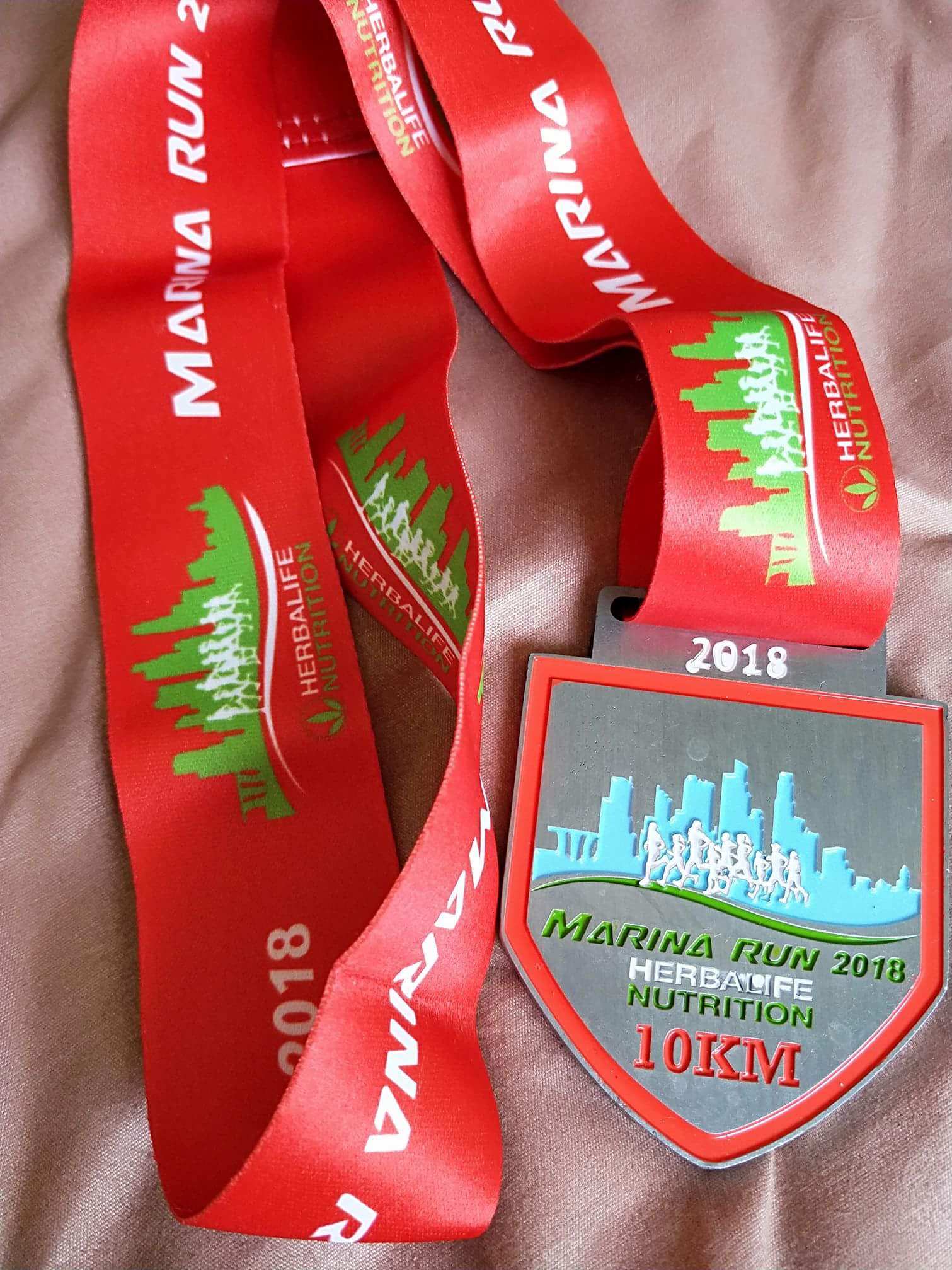
At least I got this Marina Run but anything more than 10km is very scary to me currently ? I just want to rest rest, run short and happy distance for a few months so this 10km category is just nice for me. For this run they also offered the 5km, 21km and 30km distance and the 30km is a new category.
Race fee is subjective I think, to me this race fee not cheap ? When signing up for race actually many considerations, such as brand of the race singlet, organise by which organiser, got finisher tee or medal bo or race site at where etc. But all these factors can don’t matter at all too. You happy, you want to run you will just register for the run. Though I kept complaining the race fee in Singapore sibeh expensive, but then hor the Blacksmore Sydney Marathon slot I register recently cost me USD180! ? But I know kennot lidat compare la.
On race day, I need to collect my Prosperity Walk Entry Pack at Marina Square so after that I meet my friend then we walked to the race site. I was craving for milk tea with pearls and we even detour to Marina Bay Sand’s Liho just to get it ? I was actually also dreading to run ? The Sun still sibeh bright, my eyes kennot open, and I can feel the heat. I rarely run before 7pm because of the heat and wish I can have fair skin like Snow White which is Misssion Impossible. I was wishing that there’s no cut off time to the flag off as we’re already super late but I’m still dilly dallying and determined to get my Liho.
When we reached Marina Barrage, it was just nice 5.30pm, and off goes the 10km runners running towards Bay East. By the time we went for toilet, deposited our bags, pinned our bibs, wore our shoes the last wave, wave 3 of 10km was already flagged off. It was 5.49pm when I started my Garmin, my first time ever so late for a race ? At least I turned up ?
Quite happy with my unofficial timing for this 10km as it’s my longest run after SCHKM and I’ve gained weight, not easy to carry extra kilos and run hor ? Recently just eat and eat but run very little. I’m just optimistic, convincing myself that I can lose it easily when I start preparing in a month or two for my next marathon ? Maybe that’s how I got my BMI to 29 in the past and became obese ?
I’m not a fast runner but it’s nice to be overtaking instead of being overtaken. But not always have the luxury to be overtaking in all the race and run with ease without weaving in and out unless the lanes is wide enough and without bottlenecks. I didn’t stop at any hydration points as I can feel the Liho bouncing around in my stomach ? At 5km point I noticed there’s a hydration point at the opposite direction but runners were cutting across which is pretty messy and jammed as I think it’s for runners who came back from the opposite at their 9km.
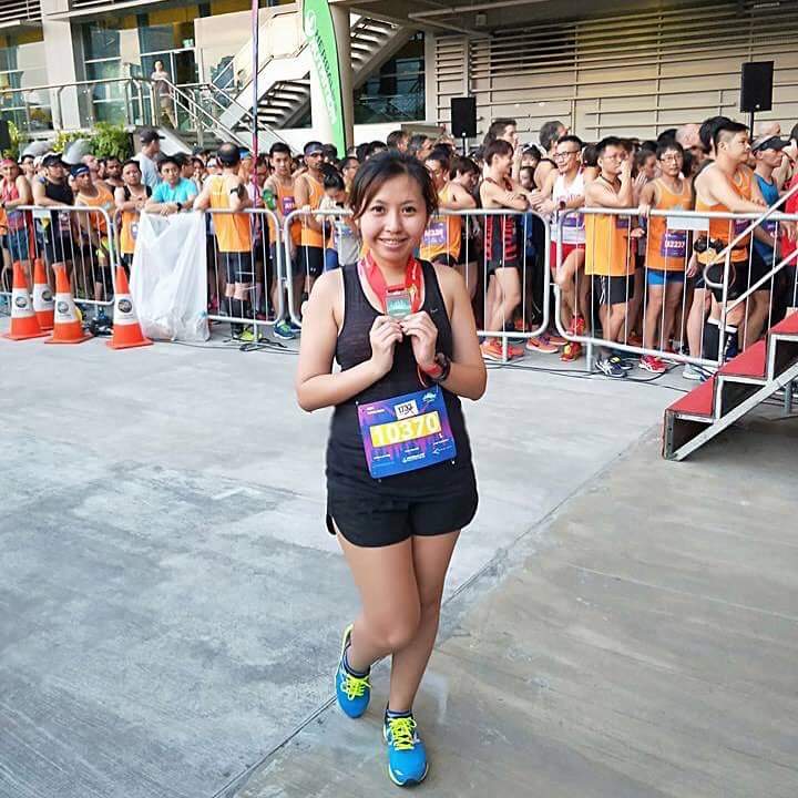
When I returned to barrage, finishing my run, the 5km runners were at the start pen waiting for their flag offs. Collected my finisher tee which was printed “10km.21km.30km” which I heard from some of my running friends complaining that it’s not “special” to the runners who put in their effort to run the extra distance. And there’s no bottled water given and we only get a small cup of water upon completion of the run ? Where got enough to drink? Erm, on one of their latest post in Facebook they asked runners to bring own bottle of reduce wastage. But not many people are used to running with bottles eh.
After finishing I saw many familiar runners and chit chat a little wishing them the best for their 21km and 30km before I went to collect my baggage. Although when I deposited my bag there’s no queue as the 10km runnners were already flagged off but when I went to collect my baggage it’s about a 20 minutes queue, with maybe just 20 runners ahead. When I was leaving, the queue was at least 100m long and I was like wish them good luck ?
Marina Barrage is not a really easy accessible place, though there’s shuttle bus service but we just Grab out. It’s still a better location than Bay East at least. I remembered last year at Bay East my shoes were all muddy. The 30km purple medal looks super nice and the 10km medal looks just nice red red and auspicious just like the Chinese New Year mood but can’t help relate the color combination the red and green of the 10km finishers medal with the Chinese tombstones I saw when I went tomb sweeping in Malaysia (Its the similar same shade of green and red some more) ?
Ever since I came back from Standard Chartered Hong Kong Marathon I’ve become a potato ? I’m just like low battery, need to recharge as I’m lazy and unmotivated to run. Happily nua-ing in my room munching Pineapple tarts. The thoughts of wanting to retire from full marathon comes up, which was supposed to be my “once in a lifetime” bucket list item to do but I’ve done it for six times already ? Really salute those runners who can easily run a marathon and even ultra marathon so frequently machiam its just a piece of cake. Anyway, I honestly had the less sore and tired legs than the rest of the marathons I had ever completed. Wonder was it because I walked a lot during the marathon or it’s the foot massage I had before and after the marathon. Quite tough to find a massage shop at ground floor along the streets as most have signboards that indicates that it’s at level 2 onwards, which I don’t want to try my luck ? The masseur has muscular arms and looks like he’s in his 40s but is already 60 years old and he told me he transferred me his 內功 (internal energy) which kept me wondering was he serious or he’s just joking ? I was screaming because he uses so much strength but he assured me it will be fine, I won’t break a bone(although I heard a few cracks) and both my foot will be very relax after that. It’s a good massage place and after the marathon, I went back immediately. ? Anyway, a few days later my itchy hands were on my phone and taaadaaaa, I’ve registered for another 42.195km to run in September in Sydney, another marathon after Gold Coast marathon in July ?
After a successful reboot last season, the Runrio Trilogy returns anew this 2018 with innovations sure to gain the interest of all from veterans to beginners. The major change this season is that the series will now expand its reach to other areas of the country beginning with Cebu City having its own version of the trilogy.
The season will commence with the Half-Marathon on March 4 in Cebu and March 18 in Metro Manila as organizers hope to better the over 15,000 attendance from 2017. Race Director Coach Rio de la Cruz promised that the Cebu races will be exactly the same as those held in Metro Manila as far as conduct of the event is concerned and they will receive the same post-race like shirts and medals.
Coach Rio also clarified that a runner can compete in different cities and still be considered a trilogy finisher. “The medals in Cebu and Manila are the same and they interlock with each other,” he said.
Aside from the main 21-kilometer race, organizers hope to gain more participants in the shorter distances of 10 and five kilometers via promos and discounts for duos to whole running teams. Online registration is now ongoing at www.runrio.com while onsite registration will be held at Olympic Village branches at Glorietta, Market Market and Ayala Center Cebu, Olympic World branches at Trinoma and Alabang Town Center and the Cebu City Sports Complex.
After the first leg, the next will feature a 32-kilometer race on May 6 in Cebu and June 3 in Metro Manila. The series will culminate with the Philippine Marathon on August 19 in Cebu and September 23 in Metro Manila.
Was one of over 400 out of 15,000 runners who completed all three races in 2017.
The launch of the 2018 Runrio Trilogy coincided with the 2017 Runrio Awards at Grand Ballroom of Okada Manila wherein more than 400 runners who completed the longest distances in all three legs were recognized and thrown a victory party. The awardees were led by Jojie Daga-as of Team Soleus who submitted the fastest accumulated time among males but fastest female and former Southeast Asian Games marathon gold winner Christabel Martes was unable to attend.
Still, Daga-as and Martes will represent the Philippines in the Bank of America Chicago Marathon this October in the United States courtesy of Gatorade. Also honored was running icon Gil Brazil as the event’s oldest finisher.
Meanwhile, the YesPinoy Foundation received PHP 500,000.00 from Runrio for its charity projects. The foundation is the main beneficiary of the Runrio Trilogy.
The Robertson twins have such a unique and inspiring story. They weren’t born African – they weren’t genetically gifted with African genes. But, they had a dream. They wanted to be among the very best in the running world. Dreams require sacrifice – so what are you willing to give up? For the Robertson twins, it was life as they knew.
At the age of 17, the Robertson twins moved to Iten, Kenya to pursue their running dream and live the African life. They left their city behind, left their family behind in pursuit of their dreams. Every athlete has probably thought of moving to Kenya, but at such a young age, no one has had the balls to do it. The Robertson twins really had the guts and determination.
Life was tough. They lived in a hut with only a mattress. They had no money, so, they only had bread and jam for a month. But, every day it was rise and grind for the both of them. They see, they want, they grind, and they get! They put in twice as much soul and effort to get to where they are now.
Their idol was Mo Farah. And, finally with hard work and grit, they both make it to the Moscow Championships. Zane even made it to the finals and was able to run alongside his idol – the legendary Mo Farah! Dreams do come true!
Look Where They Are Now
The Kiwi twins are the only 2 New Zealanders to run a 60 minute or less half marathon. Zane Robertson completed a half marathon in Japan with the time of 59:47 and his brother Jake joined him with a 60-minute flat timing at the Lisbon half marathon.
Zane currently holds the New Zealand record for the 10,000 m (27:33:67) and the half marathon (59:47). Jake has a personal best of 27:45:46 in the 10,000 m distance and 60:00:00 in the half marathon distance. They will both head to Gold Coast for the 2018 Commonwealth Games (10,000 m)and they will be a force to watch! Zane Robertson also has the option to run the marathon distance.
Hard work does pay off!
Source: Running Away From Nothing By Evan Scully; Wikipedia
Many would choose to relax and enjoy the holiday season as the year comes to an end. After all, what better way to sit back and reflect on the fruits of hard labour throughout the year?
NOPE, according to a group of runners who decided that running a relay throughout Penang Island is the very definition of ending a year with a bang!
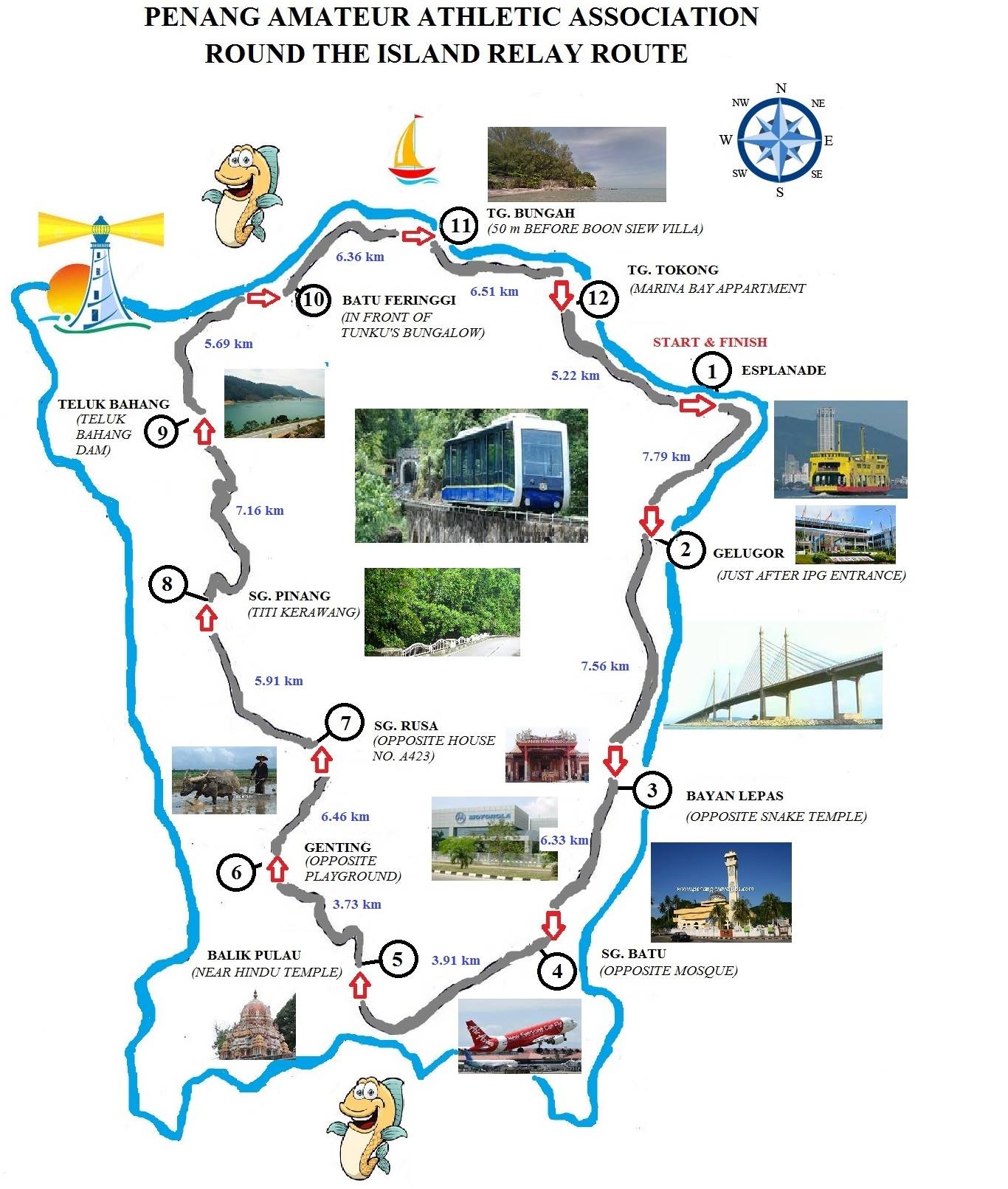
The Annual Round the Island Relay, organised by the Penang Amateur Athletics Association (PAAA), is typically held in Penang in the second week of December, with the exception of 2017, where it was pushed all the way to 31 December 2017. From a humble participation of just a few teams all the way in 1977, the relay now boasts a participation of 58 teams in 2017. Teams can choose to join any or all of the following three categories, depending on the age and gender of participating runners: Men Open, Men Veteran Open, and Mixed Team. Each team, composed of 12 runners and three substitutes, are required to run the relay through 12 checkpoints of various distances and elevations while holding a baton. The longest and shortest routes of the relay are 7.79 km (Checkpoint 1) and 3.73 km (Checkpoint 5) respectively, with the total mileage of the race set at 72.63 km.
The relay is especially exciting as it involves a great deal of strategy and teamwork, traits that are absent in the usual races. Runners are placed in their respective legs by team managers based on their capability and speed. A wrong move could cost the entire team their timing and placement.
The relay now begins at 4 am, with completion times ranging from about five hours to nine hours, depending on the overall speed of participating teams. Runners for the first leg are flagged off right in front of the City Hall Building at the Esplanade. Runners for the second and third legs are shuttled to their locations by buses prepared specially by the PAAA for the occasion. The rest of the crew are typically ferried to their checkpoints by their team managers and support system. However, runners usually end up gate-crashing all checkpoints to support their teammates and friends, turning the whole area into a cacophonous fiesta.
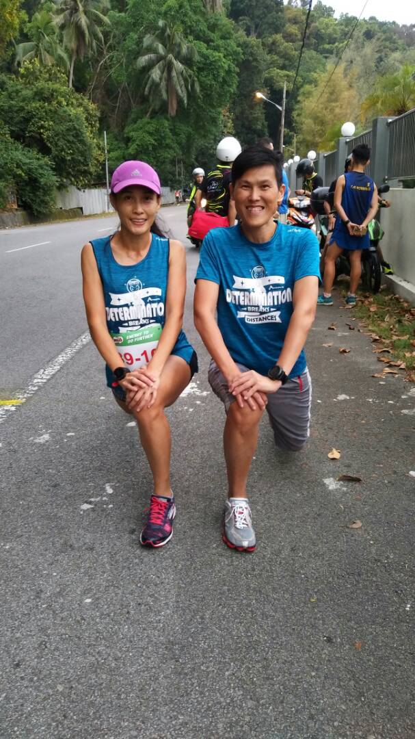
This time around, I joined team ActifeStyle Happy New Year, a Mixed-category team managed by Andrew Loh. I was designated to run the fifth leg near Balik Pulau, the shortest route of the relay. The route encompassed a few hundred metres of gentle uphill section, followed by a downhill section all the way up to the sixth checkpoint. However, I had the opportunity of visiting every checkpoint before and after my leg as Andrew drove my team mates to all the checkpoints. It was great fun witnessing the exchange of batons among all runners.
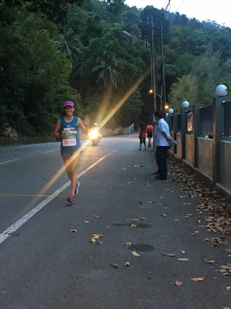
Our team began the first leg with Kho Ko King. We kept ourselves busy by cheering for all other participants while waiting for him at the second checkpoint. After passing the baton to Ricky Beh Keng Chun, we picked Kho Ko King and travelled to the third and fourth checkpoints to lend our support to Mathias Adam Maurin and Deborah Chinn. I began feeling nervous as I reached Checkpoint 5, the start of my leg. Fast male runners running in the Men Open and Men Veteran categories flitted quickly between the checkpoints as I waited for my turn to begin. The pressure to perform well increased with the knowledge that my team was ranked top three up to Checkpoint 4. The anxiety tripled when I saw Deborah approaching quickly from afar. She smiled happily as she passed the baton to me. I turned and began my quick ascent up the hill.
I was accompanied all the way by a PAAA official on a motorcycle. The route was a little narrow and dark, but I had company in the form of support cars and motorcycles of various teams who lit the way for me. Two police escorts managed the traffic locked behind me due to my humanly pace. A minor issue arose during my leg in which an impatient driver drove his car beside me and revved his machine a few times before driving away, with the police escorts hot on his heels soon after.
The downhill segment of the route was not very easy on my knees, but thankfully it was a short run. I arrived at Checkpoint 6 in 17 minutes and 11 seconds to a raucous welcome by all participants and supporters there. After passing my baton to my teammate Ewe Bee Hong, I was immediately whisked away by my team manager to follow up with the progress at the other checkpoints.
We dropped Jones Chua Wei Tiong at Checkpoint 7, a route best described as hilly, and wished him well. It was still dark as I reached Checkpoint 8, but I could hear the beautiful sounds of a waterfall in the background. As we waited with the other runners in the middle of a forest, we learnt to our dismay that a runner was accidentally dropped by his team at the wrong checkpoint. A motorcyclist who happened to pass the route at that point offered to send the runner to his correct checkpoint. As Jones arrived, we wished Ling Kee Leong good luck for the next leg, and drove to Checkpoint 9.
Map of the relay route (sourced from https://www.facebook.com/AnnualRoundTheIslandRelay/)
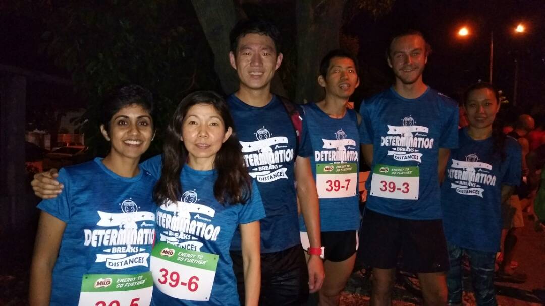
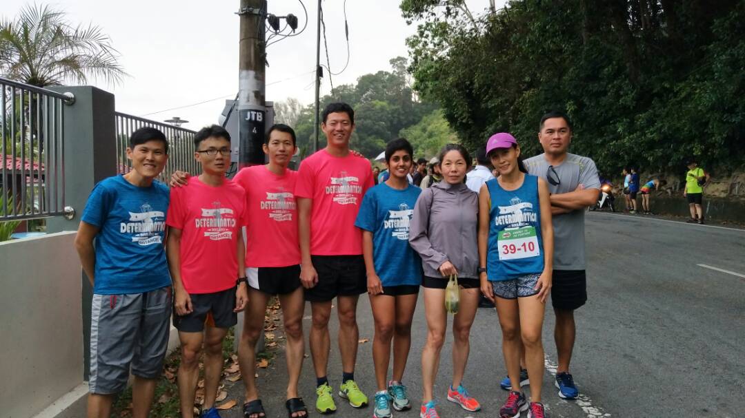
The team posing at Checkpoint 3.
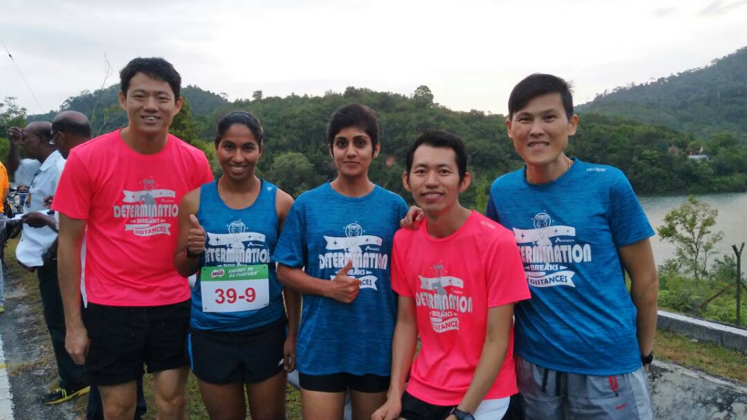
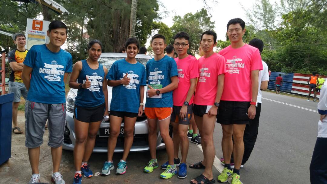
The team posing at Checkpoint 9.
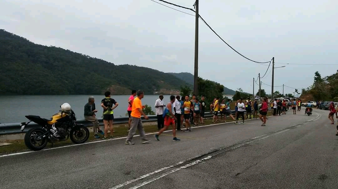
Waiting for runners at Checkpoint 9.
Woei Yann warms up at Checkpoint 10.
The team manager, Andrew, warms up with Woei Yann at Checkpoint 10.
The team posing at Checkpoint 10.
The team posing at Checkpoint 11.
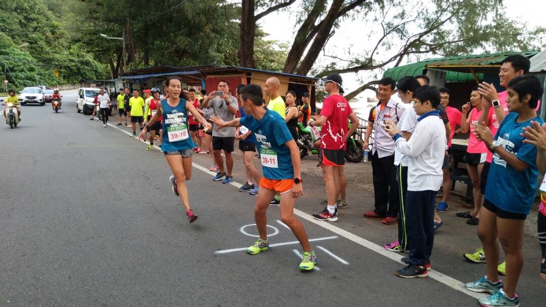
Woei Yann passing the baton to Heng Seong at Checkpoint 11.
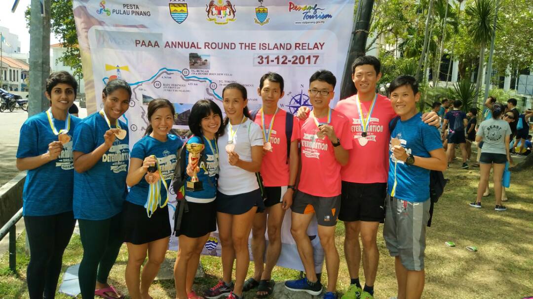
The team posing near the poster of the event.
The team posing near the map of the relay route.
Checkpoint 9 was located by the Teluk Bahang dam. A light drizzle and grey skies greeted us as we parked the car to lend our support to Nur Hazimah Idris. The air was cool and the view simply breathtaking. The relay began taking a serious turn at this point as everyone realised that mere minutes separated the top four teams in our category. After wishing Hazimah well, we immediately moved to Checkpoint 10, located by the Batu Ferringhi beach.
As we waited for Kam Woei Yann’s turn to run the 10th leg, the grey skies cleared and the sun began showing itself, despite the drizzle. Wishing for the weather to remain cool, we moved to Checkpoint 11 after Hazimah passed the baton to Woei Yann. It was also revealed at this point that we were in great danger of dropping to the fourth spot. As the baton reached the hands of Gooi Heng Seong, who ran leg 11 of the course, the O2 Hiking Club Team A was proven superior as the team pushed themselves to the third spot.
We then tailgated the final runner of our team, Mayl Yeap Yuh Jiuan, at a safe distance as she tried her best to catch up to the team before us. We drove around and parked ourselves in strategic locations just to yell uplifting words to her as she made her way in the sun to the finishing point. She was greeted by hugs and kisses from team mates and supporters as she crossed the finish line at the Esplanade, tired but happy.
The atmosphere at the Esplanade was carnival-like as teams and supporters lounged around and nibbled on snacks and food generously provided by all teams as well as the PAAA, while waiting for the other teams to arrive. A Milo van was also parked nearby, attracting a long queue that lasted quite a while. Curious tourists milled among us to query about the occasion and snap photographs.
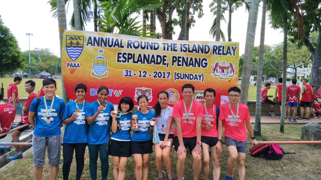
The ActifeStyle Happy New Year team managed to complete the route in 5:25:01, ranking fourth among all mixed teams. We received medals and a team trophy for our efforts. The Annual Round the Island Relay was packed with adrenaline and surprises that were worthy of an action movie. I would definitely recommend this event to runners who are seeking to end their year with a bang!

 Photo Credits: Gear Patrol

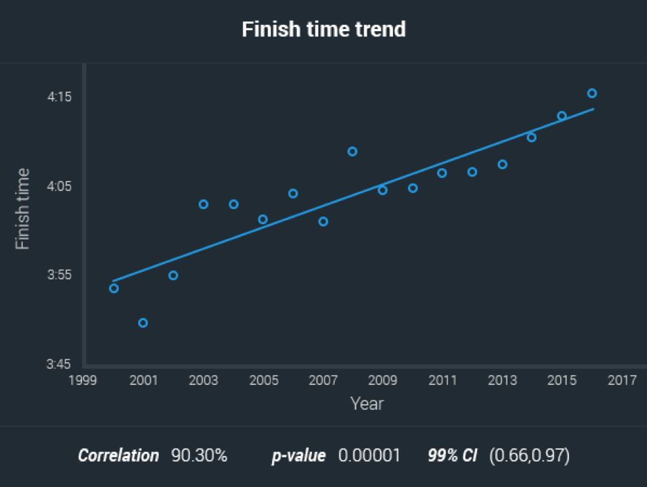
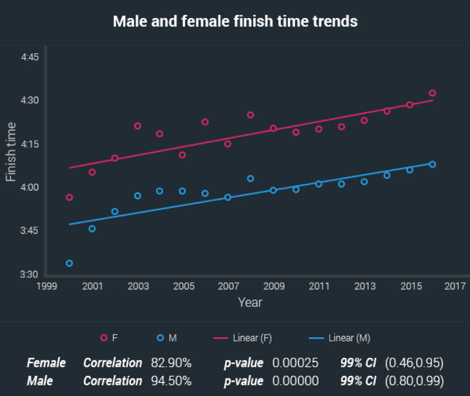
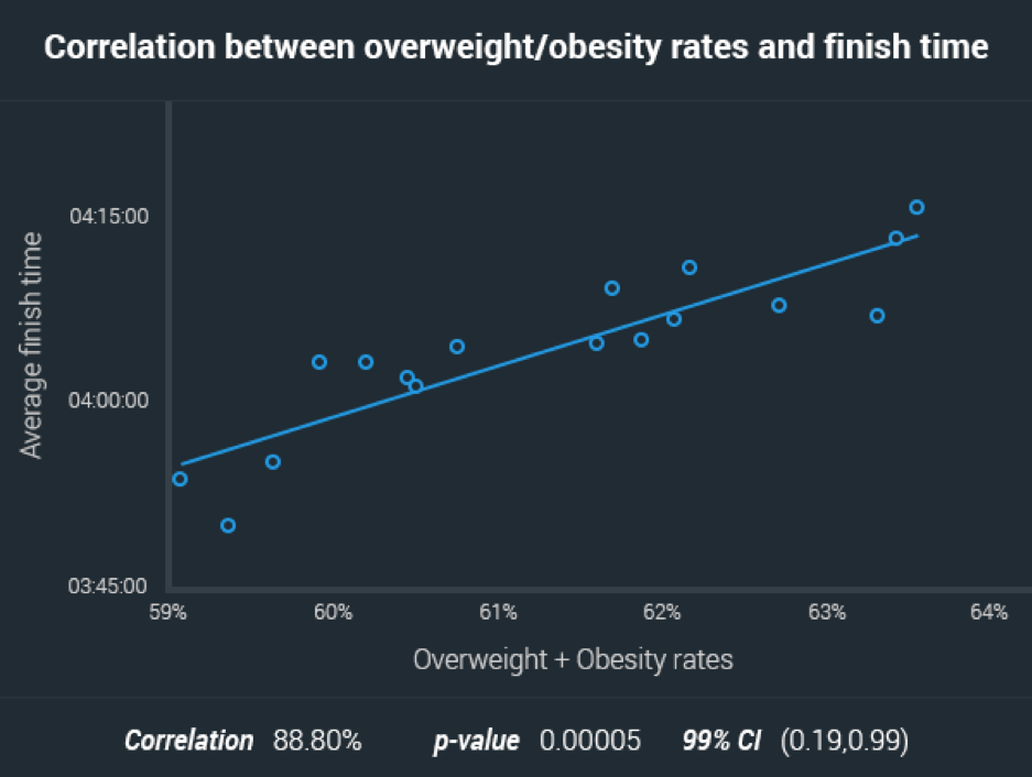
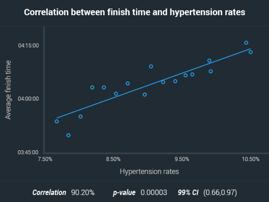


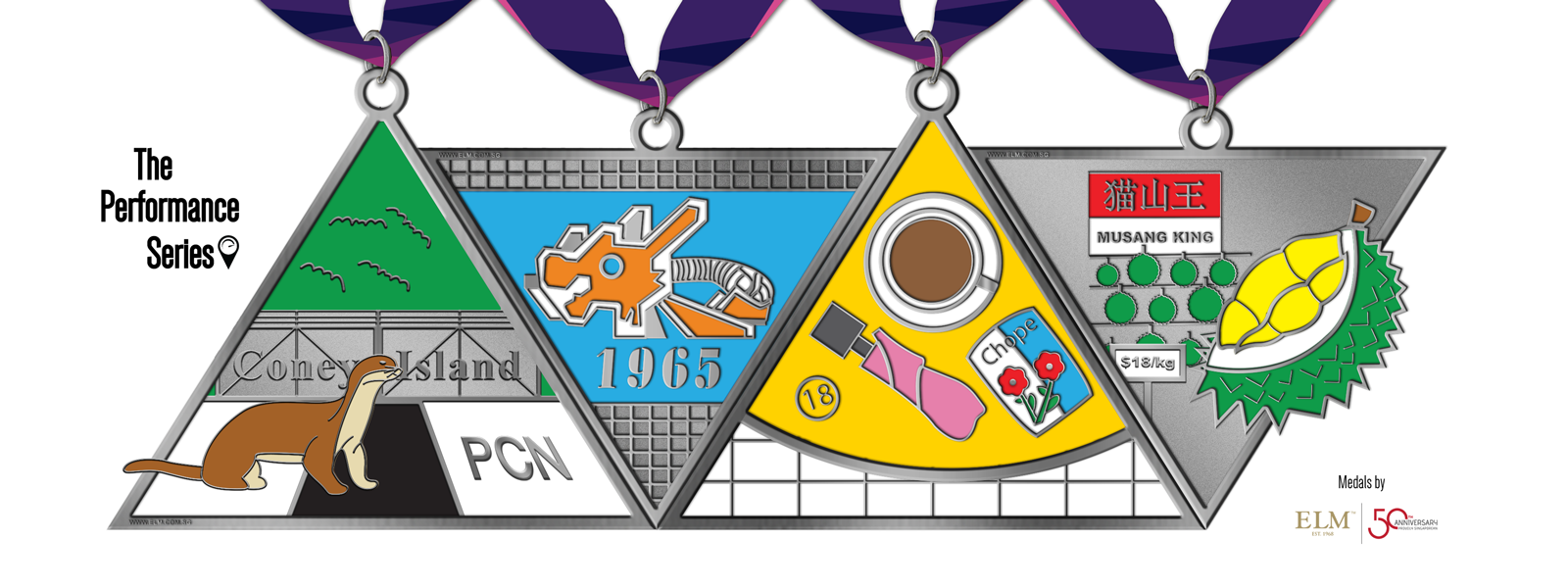
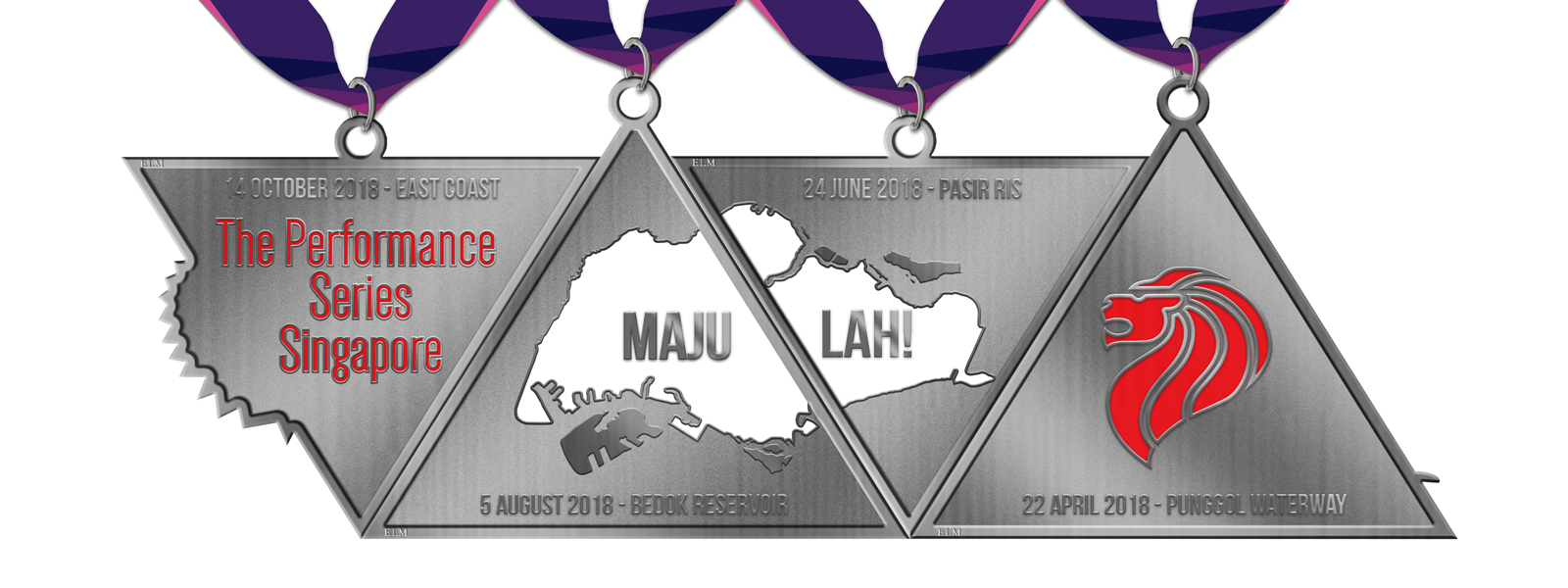
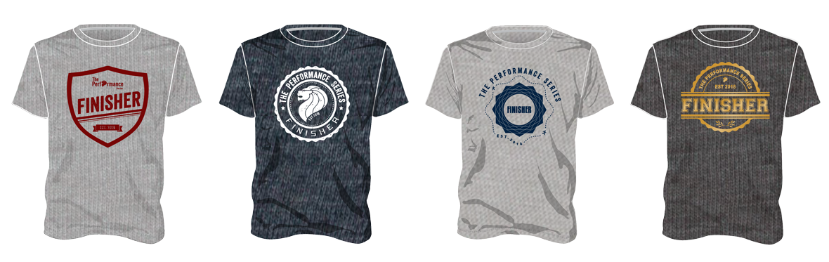


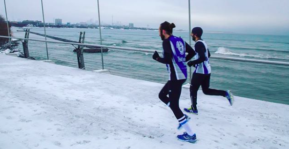


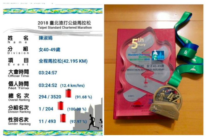

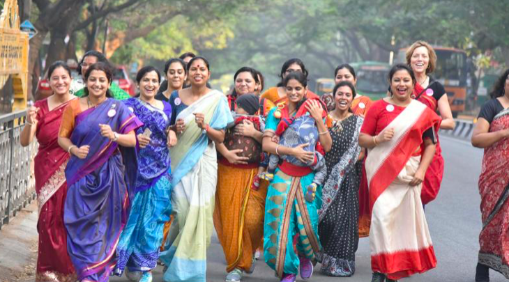 Photo Credits: Decan Chronicle
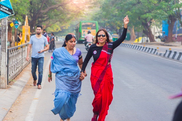 Photo Credits: The News Minute
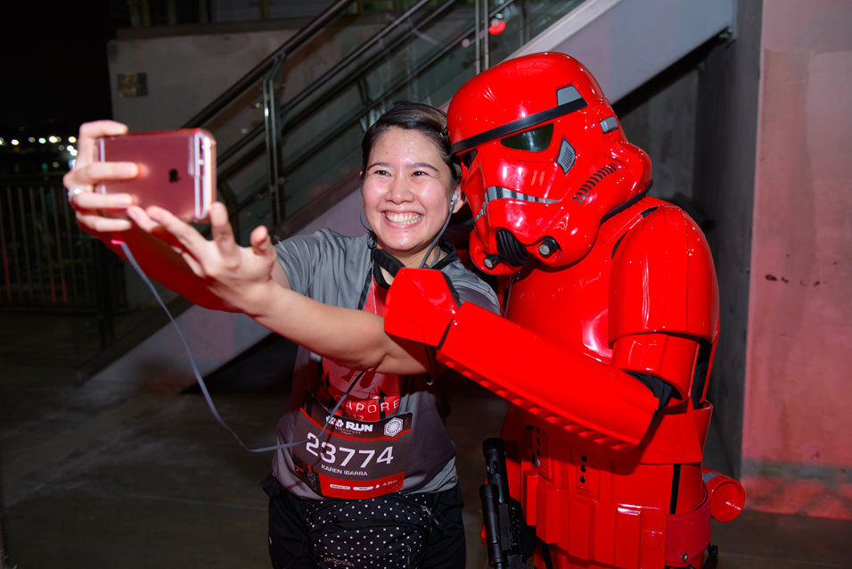
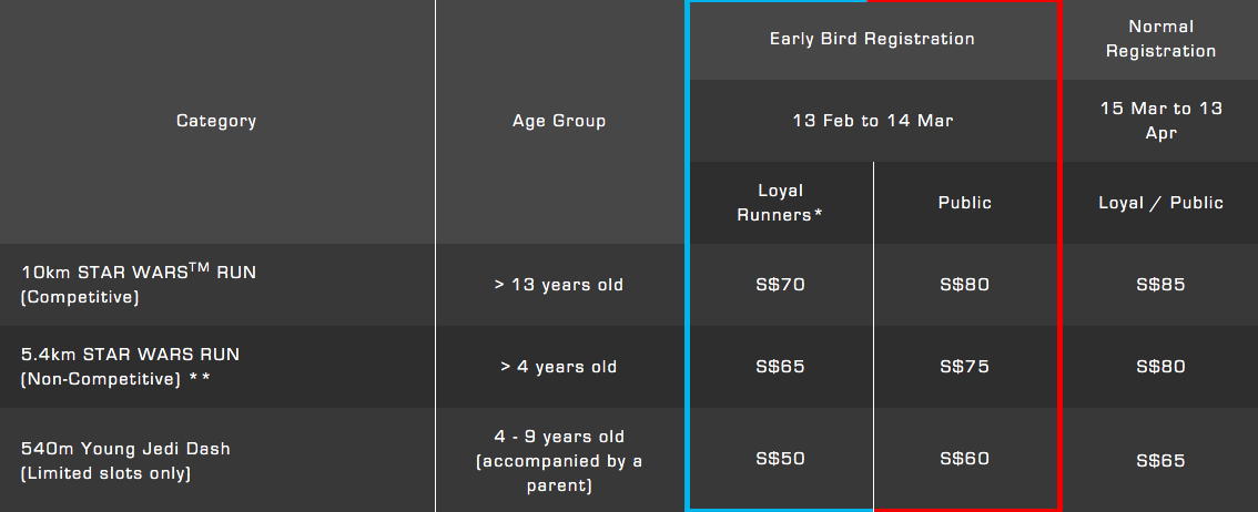

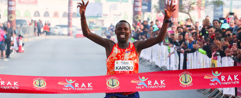 Photo Credits: Rak Half Marathon 2018
![My Marina Run 2018 [10km] (by Lingderella)](https://www.justrunlah.com/wp-content/uploads/2018/02/FB_IMG_1518324923341-768x767.jpg "My Marina Run 2018 [10km] (by Lingderella)")


")